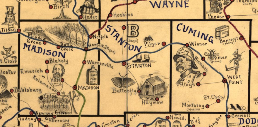
 Detail of Nebraska map - Galbraith, Frank H, and United States Railway Mail Service. Galbraith's railway mail service maps, Nebraska. Chicago, 1897, 1897. Map. https://www.loc.gov/item/98688512/. Today when I was trying to find a 1900-1910 railroad map of Nebraska, I ran across the one of the most charming maps I’ve ever seen.
In the late 19th century, Frank Galbraith, a railway mail clerk, created a set of mnemonic maps to aid railway clerks studying for Civil Service examinations. These clerks had to be able to sort mail for distribution to post offices across the US. They needed to know which rail lines serve each of the thousands of post offices, so a clerk could get the right letter on the right train. Can you imagine a railway mail clerk trying to learn the name and location of every town simply from a list of names. Yeah, the big places you know – Omaha and Lincoln. Some other crossroads towns you probably know, like York or Columbus. But Roten? Where the heck is that? Or Campbell or Franklin or Stockham, or any of scores of unconnected, random names that you just had to memorize what the name was, where it was on a map, and what railroad lines would serve that place. Boring! And hard! Names of random towns are just strings of characters, indistinguishable one from another. But the clever Frank Galbraith had a plan. He created single-purpose maps, just meant for railway clerks. They didn’t show all the geographic features such as rivers and lakes. What Galbraith focused on was “spatial proximity of place name to railroad route. His maps were hand-drawn and illustrated with images meant to represent a place name.”[1] For instance once section of the Nebraska map identifying post offices in Adams and Webster counties has images including a sailing ship, a copy, a range of 3 hills, a pair of cows, and a curve-bladed knife, representing Mayflower, Holstein, Blue Hill (yes, the hills are rendered in blue pencil), Cowles, and Bladen. In the county west of Webster, the town which shares its name with the county is represented by a sketch of the familiar founding father Franklin (Ben), while another local town, Campbell is illustrated with a camel. References to many of the images, which represented familiar faces in the late 19th century political landscape, have been lost to history. For instance, the illustration for Tilden, a town straddling the border between Madison and Antelope counties, is represented by the top-hatted Samuel J. Tilden, New York Governor and 1876 presidential candidate who lost to Rutherford B. Hayes in a contested election. The maps display much of the racial stereotypes of the time they were created. Anti African-American and anti-Asian prejudice are evident in many of the images. So too is patriotic imagery with American flags being used frequently in the maps. Virgina Mason’t article referenced in Footnote 1 below gives an in-depth history of the maps and great explanations on their symbols. You can find these charming maps on the Library of Congress website. The collection includes maps of eight states - Illinois, Iowa, Indiana, Kansas, Michigan, Minnesota, Missouri and Nebraska. Check out the link here https://www.loc.gov/search/?in=&q=galbraith+railway&new=true. When you’ve had a chance to explore, check out Humboldt, Richardson County, Nebraska. I just love the sense of whimsy in that town’s icon. Please share some of your favorite town pictures with me in the comments. [1] Virginia W. Mason, “Frank H .Galbraith’s Railway Service Maps,” Cartographic Perspectives, no. 41, Winter 2002, p. 24-43; https://cartographicperspectives.org/index.php/journal/article/view/cp41-mason.
0 Comments
|
AuthorMary Kircher Roddy is a genealogist, writer and lecturer, always looking for the story. Her blog is a combination of the stories she has found and the tools she used to find them. Archives
April 2021
Categories
All

|
