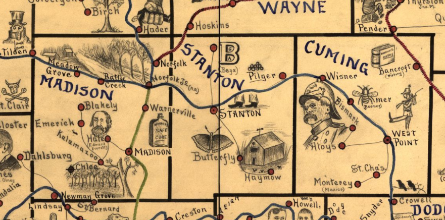
 Detail of Nebraska map - Galbraith, Frank H, and United States Railway Mail Service. Galbraith's railway mail service maps, Nebraska. Chicago, 1897, 1897. Map. https://www.loc.gov/item/98688512/. Today when I was trying to find a 1900-1910 railroad map of Nebraska, I ran across the one of the most charming maps I’ve ever seen.
In the late 19th century, Frank Galbraith, a railway mail clerk, created a set of mnemonic maps to aid railway clerks studying for Civil Service examinations. These clerks had to be able to sort mail for distribution to post offices across the US. They needed to know which rail lines serve each of the thousands of post offices, so a clerk could get the right letter on the right train. Can you imagine a railway mail clerk trying to learn the name and location of every town simply from a list of names. Yeah, the big places you know – Omaha and Lincoln. Some other crossroads towns you probably know, like York or Columbus. But Roten? Where the heck is that? Or Campbell or Franklin or Stockham, or any of scores of unconnected, random names that you just had to memorize what the name was, where it was on a map, and what railroad lines would serve that place. Boring! And hard! Names of random towns are just strings of characters, indistinguishable one from another. But the clever Frank Galbraith had a plan. He created single-purpose maps, just meant for railway clerks. They didn’t show all the geographic features such as rivers and lakes. What Galbraith focused on was “spatial proximity of place name to railroad route. His maps were hand-drawn and illustrated with images meant to represent a place name.”[1] For instance once section of the Nebraska map identifying post offices in Adams and Webster counties has images including a sailing ship, a copy, a range of 3 hills, a pair of cows, and a curve-bladed knife, representing Mayflower, Holstein, Blue Hill (yes, the hills are rendered in blue pencil), Cowles, and Bladen. In the county west of Webster, the town which shares its name with the county is represented by a sketch of the familiar founding father Franklin (Ben), while another local town, Campbell is illustrated with a camel. References to many of the images, which represented familiar faces in the late 19th century political landscape, have been lost to history. For instance, the illustration for Tilden, a town straddling the border between Madison and Antelope counties, is represented by the top-hatted Samuel J. Tilden, New York Governor and 1876 presidential candidate who lost to Rutherford B. Hayes in a contested election. The maps display much of the racial stereotypes of the time they were created. Anti African-American and anti-Asian prejudice are evident in many of the images. So too is patriotic imagery with American flags being used frequently in the maps. Virgina Mason’t article referenced in Footnote 1 below gives an in-depth history of the maps and great explanations on their symbols. You can find these charming maps on the Library of Congress website. The collection includes maps of eight states - Illinois, Iowa, Indiana, Kansas, Michigan, Minnesota, Missouri and Nebraska. Check out the link here https://www.loc.gov/search/?in=&q=galbraith+railway&new=true. When you’ve had a chance to explore, check out Humboldt, Richardson County, Nebraska. I just love the sense of whimsy in that town’s icon. Please share some of your favorite town pictures with me in the comments. [1] Virginia W. Mason, “Frank H .Galbraith’s Railway Service Maps,” Cartographic Perspectives, no. 41, Winter 2002, p. 24-43; https://cartographicperspectives.org/index.php/journal/article/view/cp41-mason.
0 Comments
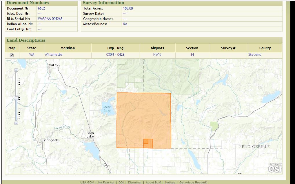 Map from Bureau of Land Management showing location of property of Arvilla Fowell in Stevens County, Washington Sometimes when you look at a census you get lucky. The census enumerator wrote the street names down the left side of the census page and filled in the house numbers so 100 years later, you can see exactly where your ancestor lived. But other times you get pages like the ones W. G. Campbell wrote for the Gardenspot Precinct of Stevens County, Washington in 1910 – no street names and no numbers to pinpoint the position of any of the 30-some households he enumerated. With no street names or numbers, is there any way to zero in on the location?
Yes! Land records may be the key. Look at the census to find which households owned property. Track down the locations of the property using the grantee index to find when those owners bought their properties and the book and page where the deed can be found. Using the property descriptions, map the property location. Though some people may have rented and not owned, if you have enough owners, you can probably determine the enumerator’s route and extrapolate where the renters’ homes were located. Start by looking in the FamilySearch catalog for your county and state of interest and selecting land records. If you’re lucky, FamilySearch will have digitized images of the indexes and deed. If not, you may need to either request the microfilms of the indexes and deeds be sent to your local Family History Center or contact the county in question to get copies of the deeds. For some locations and time frames, you may find information on the Bureau of Land Management General Land Office Records website (https://glorecords.blm.gov/search/). Search for your ancestor and his neighbors. If they received their land directly from the federal government, perhaps by a homestead application or a cash sale, they will be listed on this site. Look for all the neighbors, and find their Township, Range and Section numbers. People near one another on the census are likely to be in the same Township and Range, and if they are not in the same section, they will be in adjacent sections. There are 36 sections in each Township and Range combination, in a six-by-six grid. (Jacksonville State University has a webpage illustrating and explaining the Township and Range system at http://www.jsu.edu/dept/geography/mhill/phygeogone/trprac.html). A researcher recently posted a query on a facebook group about one of W. G. Campbell’s Stevens County no-address-listed 1910 census pages. She wanted to know how to find where her ancestor lived. I couldn’t find Stevens county deeds on FamilySearch, but I looked at the BLM-GLO site and started searching for names. On the 1910 census I found household visitation numbers for various households, including neighbors Abbott (151), Tinnell (153), Fowell (154), and Belton (155)..[i] The table below identifies a property location for each household: Visit # Surname Township Range Sect Description 151 Abbott 030N 042E 32 NW ¼ NE ¼[ii] 153 Tinnell 030N 042E 32 NW ¼ SE ¼ and S ½ SE ¼[iii] 154 Fowell (Bailey) 030N 042E 34 NW ¼[iv] 155 Belton 030N 042E 28 SE ¼[v] The facebook researcher’s family of interest was Neafus, visitation number 157. Though Neafus is shown on the 1910 census as owning property, he is not listed on the BLM site. It is likely that Neafus purchased the property from the original government grantee. In order to find Neafus’ deed, one would need to look in the deed books for Stevens County to get the exact property description, but it is likely to be in Section 28 or an adjacent section. A couple of map sites will help. The BLM-GLO website has maps of the properties. Once you identify the property you are researching, you can click on the Map box in the center of the page, and a map will appear showing the township and range, the various sections, highlighting the location of the property of interest. You can continue to zoom in and see the roads. This will enable you to map the properties and look at the roads to see the path the enumerator took to reach his or her assigned households. In the case of the facebook question, I’ve mapped out that the enumerator traveled southeast on Garden Spot Road to interview Abbott and Tinnell and then took a left on Keenan Road, heading north, first meeting Fowell and then Belton. Neafus is two households after Belton, and is likely in an adjacent parcel. Securing of copy of Neafus’ deed will identify exactly which parcel is his, but even with what I’ve researched here, I’ve identified pretty good idea of where Neafus lived, even without an address listed on the census. Try using maps along with the census. They can be helpful to learn more about your ancestors and their world. And they might even pinpoint just where your ancestor lived. [i] "United States Census, 1910," database with images, FamilySearch (https://familysearch.org/ark:/61903/1:1:MGVH-9JQ : accessed 14 March 2017), Arvilla Fowell in household of James Fowell, Gardensport, Stevens, Washington, United States; citing enumeration district (ED) ED 230, sheet 9A, family 154, NARA microfilm publication T624 (Washington D.C.: National Archives and Records Administration, 1982), roll 1672; FHL microfilm 1,375,685. [ii] Bureau of Land Management, “Land Patent Search,” digital images, General Land Office Records (http://www.glorecords.blm.gov/PatentSearch : accessed 14 March 2017), Abbott, Andrew P. (Stevens County, Washington), document number WASP 0003009. [iii] Bureau of Land Management, “Land Patent Search,” digital images, General Land Office Records (http://www.glorecords.blm.gov/PatentSearch : accessed 14 March 2017), Tinnell, James G (Stevens County, Washington), document number WASP 0001270. [iv] Bureau of Land Management, “Land Patent Search,” digital images, General Land Office Records (http://www.glorecords.blm.gov/PatentSearch : accessed 14 March 2017), Fowell, Arvilla – Bailey, Arvilla (Stevens County, Washington), document number WASPAA 009268. Arvilla Bailey, a widow, married James Fowell. The property on which they are enumerated in the census is recorded under Arvilla's name. James Fowell does appear to own property elsewhere in Stevens County acording to the land records. [v] Bureau of Land Management, “Land Patent Search,” digital images, General Land Office Records (http://www.glorecords.blm.gov/PatentSearch : accessed 14 March 2017), Belton, James (Stevens County, Washington), document number WASPAA 009324. Normally I post my Tuesday tips on Tuesday. But I've been so busy researching in the FamilyHistoryLibrary I'm a day late. Hope you don't mind... I think this one's worth the wait.. I recently discovered a new-to-me Irish resource. I have Irish Catholic ancestors on both my side and my husband, Mark’s side. I’ve spent the last several days in the Family History Library in Salt Lake City trying to get a handle on the geography of where some of them lived and I found a wonderful website that is helping me do that. The site is www.swilson.info I’ve spent some time trying to figure out who SWilson is. I don’t even know if S is male or female but I do know that I love love love him or her! One of my favorite things on the site is a “Church and Catholic Parish Search.” According to the website, “This option searches for the closest Catholic Chapel to a selected location based on Chapel locations as they were in the late 1830s and early 1840s.” I have been able to determine the place of origin for some of Mark’s ancestors from records in the US and tracing back to Ireland to discover where four known children were baptized. I believe I’ve also found a marriage record for the parents, not in the same church, but in a different, nearby parish. I’ve also used Griffith’s Valuation and some Tithe Applotment Books to ascertain a townland. But using www.swilson.info, I can establish exactly where the parish church for the baptism is, and find the nearby churches. Here’s how I did it. Look at http://www.swilson.info/gmapsetcoords.php. You will see a yellow search marker. Drag the marker and drop it on the map close to where your person of interest lived. You can zoom in on the map to refine the location using the +/- buttons in the lower right corner of the map. 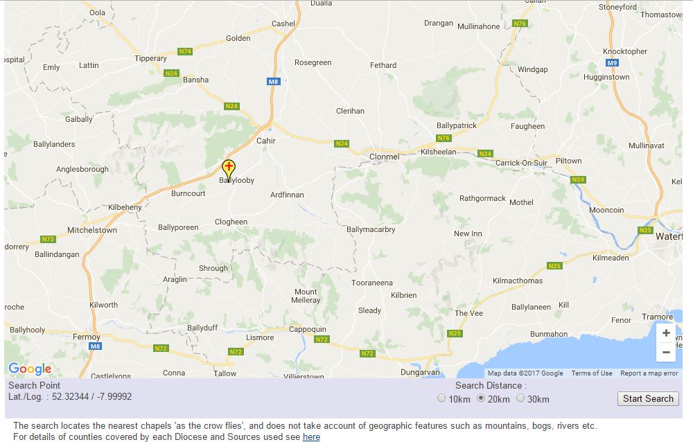 SWilson.info - http://www.swilson.info/gmapsetcoords.php Once you’re narrowed in to the approximate location of where your ancestors lived, click on the “Start Search” button in the lower right corner. Colored pointers will pop up all over the map showing all the Catholic churches. On the right side of the map is a key naming the parish and the church. If you click on the “Show Parish Details” icon between the columns you’re taken to a new screen, full of information, including the Roman Catholic Diocese, the linked Civil Parishes, a list of nearby parishes with notations of how far away they are and in what direction. 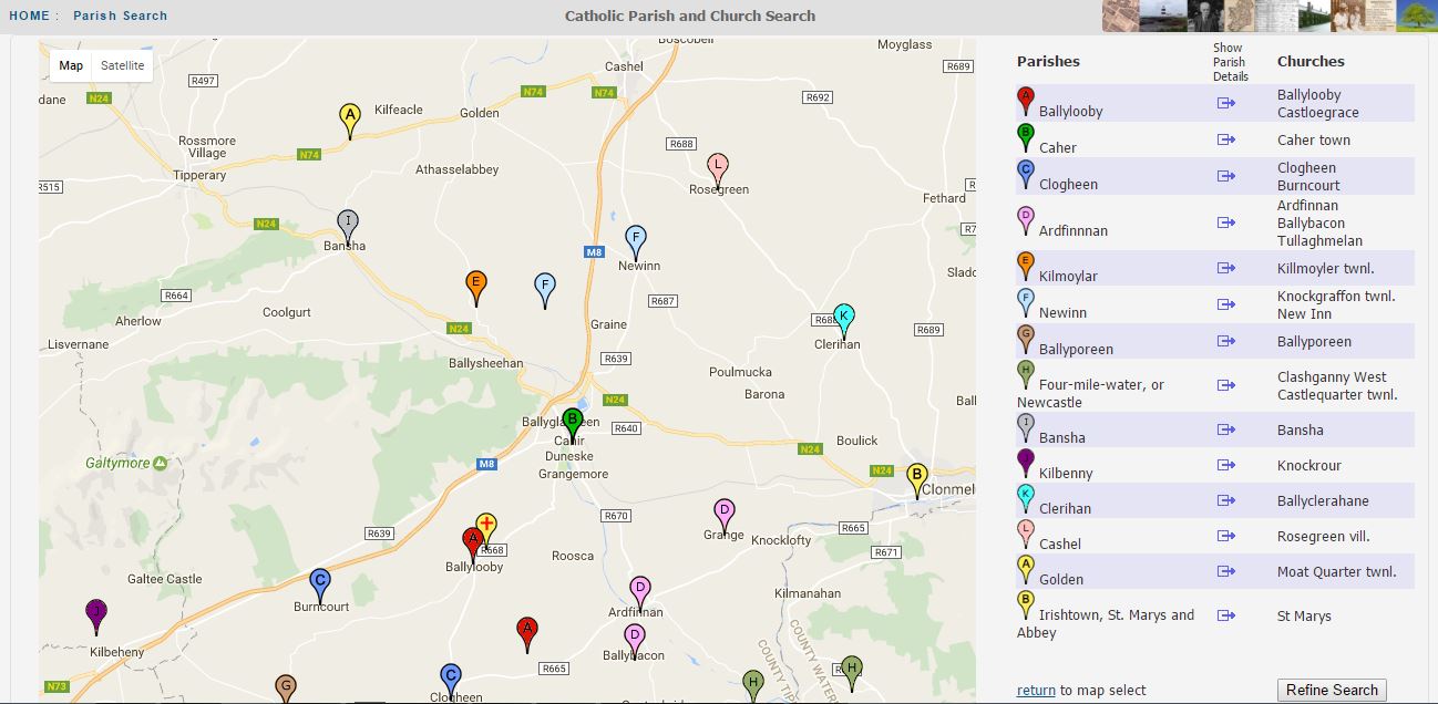 SWilson.info - Roman Catholic Parish Coordinates Search showing nearby parishes - http://www.swilson.info/rcparishcoordsrch.php My favorite part, however, is smack dab in the middle of the screen where there is a link to the NLI (National Library of Ireland) Film Details and Website. Once there, you can select the relevant register for baptisms, marriages (or death in some cases) and then filter by selecting the year and month if you know it. 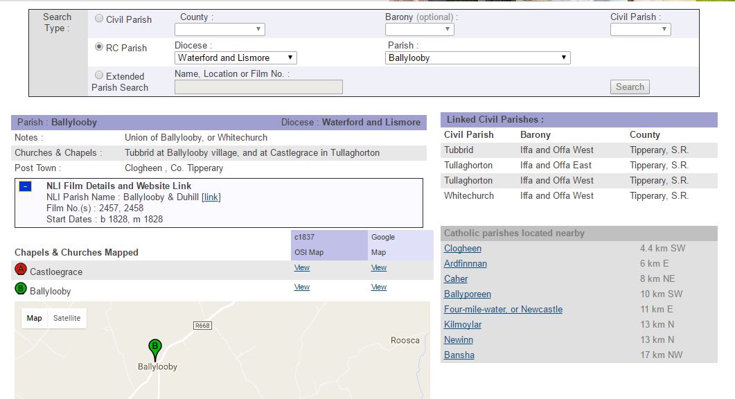 SWilson.info Catholic and Civil Parish Links My favorite part, however, is smack dab in the middle of the screen where there is a link to the NLI (National Library of Ireland) Film Details and Website. Once there, you can select the relevant register for baptisms, marriages (or death in some cases) and then filter by selecting the year and month if you know it. SWilson.info is gem of a site, allowing the researcher to point to a location in Ireland, and drill down to the relevant available parish registers. Thank you SWilson, whoever you are! You’re my new fave. |
AuthorMary Kircher Roddy is a genealogist, writer and lecturer, always looking for the story. Her blog is a combination of the stories she has found and the tools she used to find them. Archives
April 2021
Categories
All

|
