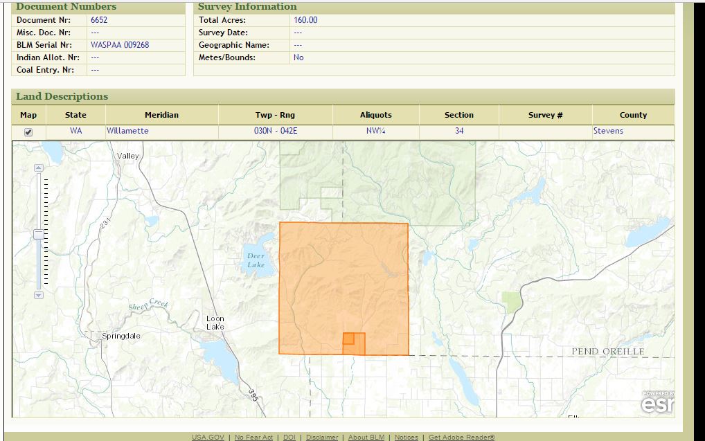
 Map from Bureau of Land Management showing location of property of Arvilla Fowell in Stevens County, Washington Sometimes when you look at a census you get lucky. The census enumerator wrote the street names down the left side of the census page and filled in the house numbers so 100 years later, you can see exactly where your ancestor lived. But other times you get pages like the ones W. G. Campbell wrote for the Gardenspot Precinct of Stevens County, Washington in 1910 – no street names and no numbers to pinpoint the position of any of the 30-some households he enumerated. With no street names or numbers, is there any way to zero in on the location?
Yes! Land records may be the key. Look at the census to find which households owned property. Track down the locations of the property using the grantee index to find when those owners bought their properties and the book and page where the deed can be found. Using the property descriptions, map the property location. Though some people may have rented and not owned, if you have enough owners, you can probably determine the enumerator’s route and extrapolate where the renters’ homes were located. Start by looking in the FamilySearch catalog for your county and state of interest and selecting land records. If you’re lucky, FamilySearch will have digitized images of the indexes and deed. If not, you may need to either request the microfilms of the indexes and deeds be sent to your local Family History Center or contact the county in question to get copies of the deeds. For some locations and time frames, you may find information on the Bureau of Land Management General Land Office Records website (https://glorecords.blm.gov/search/). Search for your ancestor and his neighbors. If they received their land directly from the federal government, perhaps by a homestead application or a cash sale, they will be listed on this site. Look for all the neighbors, and find their Township, Range and Section numbers. People near one another on the census are likely to be in the same Township and Range, and if they are not in the same section, they will be in adjacent sections. There are 36 sections in each Township and Range combination, in a six-by-six grid. (Jacksonville State University has a webpage illustrating and explaining the Township and Range system at http://www.jsu.edu/dept/geography/mhill/phygeogone/trprac.html). A researcher recently posted a query on a facebook group about one of W. G. Campbell’s Stevens County no-address-listed 1910 census pages. She wanted to know how to find where her ancestor lived. I couldn’t find Stevens county deeds on FamilySearch, but I looked at the BLM-GLO site and started searching for names. On the 1910 census I found household visitation numbers for various households, including neighbors Abbott (151), Tinnell (153), Fowell (154), and Belton (155)..[i] The table below identifies a property location for each household: Visit # Surname Township Range Sect Description 151 Abbott 030N 042E 32 NW ¼ NE ¼[ii] 153 Tinnell 030N 042E 32 NW ¼ SE ¼ and S ½ SE ¼[iii] 154 Fowell (Bailey) 030N 042E 34 NW ¼[iv] 155 Belton 030N 042E 28 SE ¼[v] The facebook researcher’s family of interest was Neafus, visitation number 157. Though Neafus is shown on the 1910 census as owning property, he is not listed on the BLM site. It is likely that Neafus purchased the property from the original government grantee. In order to find Neafus’ deed, one would need to look in the deed books for Stevens County to get the exact property description, but it is likely to be in Section 28 or an adjacent section. A couple of map sites will help. The BLM-GLO website has maps of the properties. Once you identify the property you are researching, you can click on the Map box in the center of the page, and a map will appear showing the township and range, the various sections, highlighting the location of the property of interest. You can continue to zoom in and see the roads. This will enable you to map the properties and look at the roads to see the path the enumerator took to reach his or her assigned households. In the case of the facebook question, I’ve mapped out that the enumerator traveled southeast on Garden Spot Road to interview Abbott and Tinnell and then took a left on Keenan Road, heading north, first meeting Fowell and then Belton. Neafus is two households after Belton, and is likely in an adjacent parcel. Securing of copy of Neafus’ deed will identify exactly which parcel is his, but even with what I’ve researched here, I’ve identified pretty good idea of where Neafus lived, even without an address listed on the census. Try using maps along with the census. They can be helpful to learn more about your ancestors and their world. And they might even pinpoint just where your ancestor lived. [i] "United States Census, 1910," database with images, FamilySearch (https://familysearch.org/ark:/61903/1:1:MGVH-9JQ : accessed 14 March 2017), Arvilla Fowell in household of James Fowell, Gardensport, Stevens, Washington, United States; citing enumeration district (ED) ED 230, sheet 9A, family 154, NARA microfilm publication T624 (Washington D.C.: National Archives and Records Administration, 1982), roll 1672; FHL microfilm 1,375,685. [ii] Bureau of Land Management, “Land Patent Search,” digital images, General Land Office Records (http://www.glorecords.blm.gov/PatentSearch : accessed 14 March 2017), Abbott, Andrew P. (Stevens County, Washington), document number WASP 0003009. [iii] Bureau of Land Management, “Land Patent Search,” digital images, General Land Office Records (http://www.glorecords.blm.gov/PatentSearch : accessed 14 March 2017), Tinnell, James G (Stevens County, Washington), document number WASP 0001270. [iv] Bureau of Land Management, “Land Patent Search,” digital images, General Land Office Records (http://www.glorecords.blm.gov/PatentSearch : accessed 14 March 2017), Fowell, Arvilla – Bailey, Arvilla (Stevens County, Washington), document number WASPAA 009268. Arvilla Bailey, a widow, married James Fowell. The property on which they are enumerated in the census is recorded under Arvilla's name. James Fowell does appear to own property elsewhere in Stevens County acording to the land records. [v] Bureau of Land Management, “Land Patent Search,” digital images, General Land Office Records (http://www.glorecords.blm.gov/PatentSearch : accessed 14 March 2017), Belton, James (Stevens County, Washington), document number WASPAA 009324.
2 Comments
Lisa Gorrell
3/22/2017 08:24:32 am
My cousin and I were talking about finding the land of our ancestor and this is just the method we need. Thank you very much! Perfect timing.
Cheri
7/21/2018 09:22:35 pm
Mary, what about this resource: http://www.earthpoint.us/Townships.aspx Your comment will be posted after it is approved.
Leave a Reply. |
AuthorMary Kircher Roddy is a genealogist, writer and lecturer, always looking for the story. Her blog is a combination of the stories she has found and the tools she used to find them. Archives
April 2021
Categories
All

|
